6T3

When the most sensor-laden, stiffly sprung racing cars on the planet are driven at 200mph in state-of-the-art simulations, there’s nowhere for poor quality point cloud data to hide.  That’s why 6T3 delivers Data Certainty to its customers.

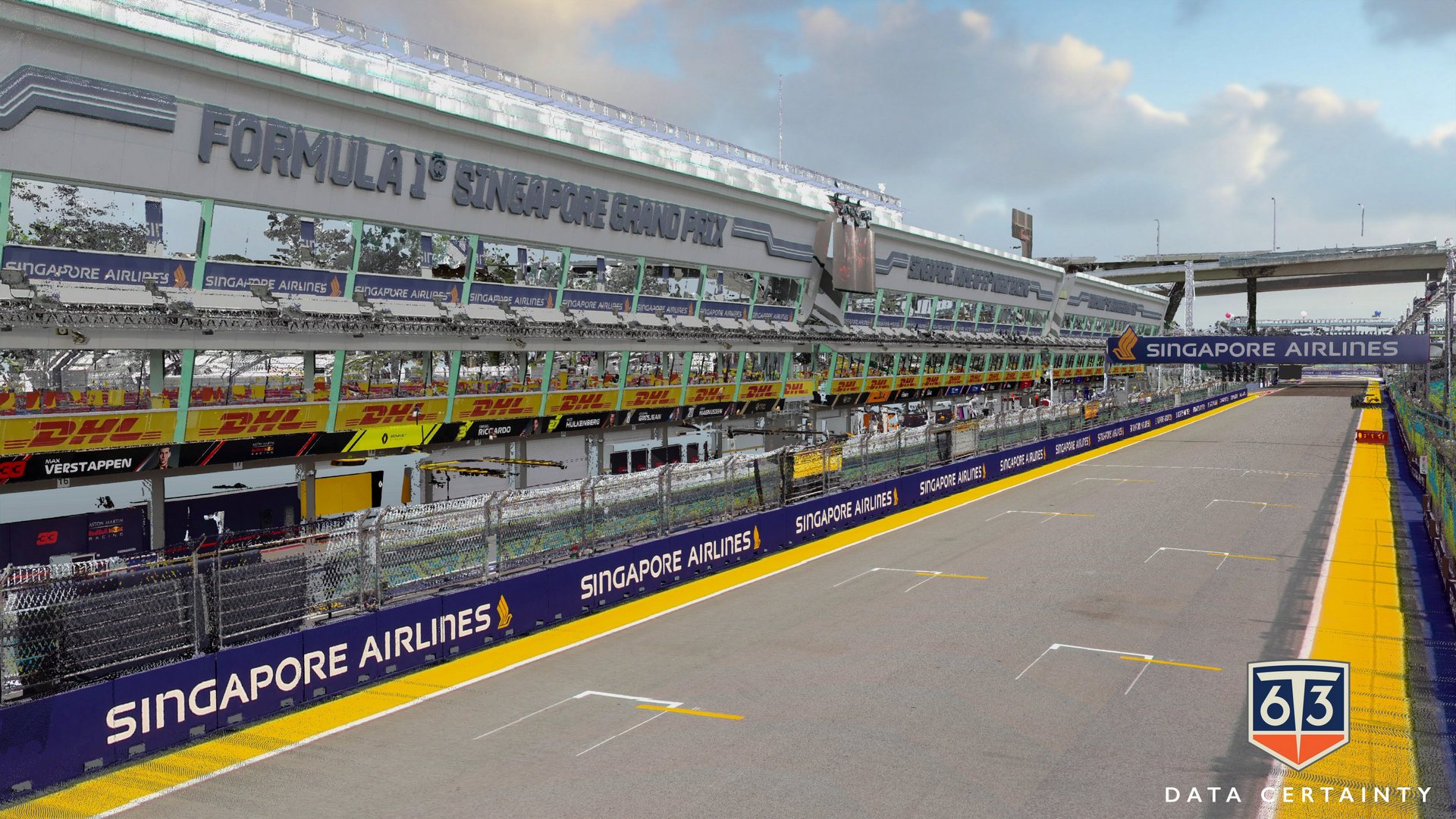
"6T3 have supplied engineering-quality LiDAR data to Racing Point F1 ... for use in our driver-in-the-loop simulator. We have found 6T3 to be flexible, innovative and reliable, and the supplied data have always been of very high quality. One aspect of the relationship that we have appreciated is the honesty and openness ... we have always been made aware of any challenging aspects of a particular dataset in advance of purchase ...”

Around the globe, industry relies upon good data, but the reality is that data often fail to measure up.  When billions of dollars are on the line, Formula 1™ teams, vehicle manufacturers, and enterprises building the next generation of autonomous vehicles know that making decisions based upon data certainty is like making decisions based upon facts rather than perceptions.

Capturing data with impeccable accuracy and interpreting those data with a combination of science, engineering, and artistry is at the heart of 6T3.  We are passionate about the strategic use of data and we understand how the data can be used and for what purposes.

We’re all about the numbers.  Quite simply, this is our passion and this is who we are.

Company Overview

6T3 was established in 2007, when we were the first in the world to introduce highly reliable terrestrial mobile mapping LiDAR systems and their resultant datasets into the simulation departments of the world’s most demanding users – namely, Formula 1™ motor racing teams.

Having developed the racetrack scanning market, 6T3 has gained acceptance from the entire Formula 1™ community and taken its place as the market leader, providing precise mapping solutions for Formula 1™, NASCAR®, IndyCar®, and the FIA World Endurance Championship (WEC).

We have also developed breakthrough solutions with both mainstream automotive manufacturers and the military of a number of nations around the globe.

With more than 80 years of combined experience in GNSS, INS, laser scanners and systems integration, our team has continually explored and pushed the boundaries of what is technically feasible.

Our clients need highly accurate surface models and we provide the best, most reliable interpreted pointcloud data in the world.

Pinpoint Accuracy, Extraordinary Reliability:
About Our Process

6T3’s unique mobile mapping LiDAR systems measure up to 2 million points per second, resulting in thousands of precise points per square metre.  Our proprietary capture and processing workflows result in the cleanest and most reliable pointcloud datasets in the industry, allowing our clients to produce equally reliable simulation models.

Our systems are not “black box”.  6T3’s mapping systems are custom built, integrating the best, and most appropriate, sensors that are available, with no compromise on accuracy and quality. 

We understand the limitations and capabilities of terrestrial mapping, and our unique processing workflows have been built from the ground up to ensure that we produce the best possible data for our clients.

Mobile mapping is not a simple process, in fact it takes a significant element of craft to achieve the consistently reliable and accurate data for which we are known. This is due to our unique breadth and depth of knowledge and experience.

The Technology & Data

Our bespoke, proprietary mobile mapping systems tightly integrate two discrete types of laser scanning technologies with state-of-the-art GNSS and inertial systems.  Superior field data acquisition techniques, unique data processing techniques, and rigorous quality assurance result in highly accurate laser scans of terrestrial surfaces and the surrounding environment.

Typical deliverables for simulation applications:

Play Video

Accomplishments

We are passionate about what we do, whether it’s surveying racetracks for Formula 1™ teams, scanning automotive proving grounds, mapping test ranges for the military, or conducting road surveys for national and state highway authorities.  6T3 has been in this business for over 15 years, and we pride ourselves on the quality of our work.  Here are just a few of our accomplishments in this time:

About the 6T3 Team

80 years of scanning expertise and innovation at the highest level

Chris Cox

DR. CHRIS COX
Production Director

Dr. Chris Cox is the Production Director for 6T3, and is responsible for data production and developing software and workflows for data processing.  During his 15 years in the LiDAR industry Chris helped develop the first commercially available mobile mapping system, and went on to develop many more ground-breaking systems that helped shape current trends in mobile mapping.  Specialising in both mobile and airborne mapping, Chris is highly skilled in geomatics, surveying, software development, computer-aided design, and strategic planning.  A strong engineering professional, Chris has a PhD focused in Environmental Engineering from The University of Nottingham.

Kresimir Kusevic

KRESIMIR KUSEVIC
Technical Director

Kresimir Kusevic is the Technical Director for 6T3, involved in the design and development of new mobile mapping LiDAR systems.  He received his Masters in Geodesy Engineering from the University of Zagreb, Croatia in 1990.  In the early nineties, Kresimir developed a differential kinematic GPS processor suite and a Vehicle Location System.  He was involved in research, prototyping and development of low-range airborne LiDAR systems, and invented the world’s first mobile terrestrial LiDAR system.  Since joining 6T3 in 2014 he has developed several state-of-the-art survey grade mobile mapping systems including the world’s first high-definition LiDAR backpack system.  Kresimir has collaborated extensively with academic institutions, working on various LiDAR and camera calibration studies, and has published and co-authored several scientific papers.

Simon Newby

SIMON NEWBY
Company Director

Simon Newby graduated from North East London Polytechnic with a degree in Surveying & Mapping Sciences in 1984, and from the University of New Brunswick in 1992 with a MScE in Surveying Engineering. Nowadays, he is the President and owner of 6T3.  It was whilst working with the first mobile mapping system of its kind in 2005 that Simon had the idea of using the output from these types of systems for producing high-end simulations for the world's most demanding users – F1 motor racing teams.  Thus, in 2007, 6T3 was born. Simon has been a motor racing fan (and general petrol head) since he was a small boy, thus, the marriage of his professional training with one of his lifelong personal passions represents “the dream job”.

6T3

Learn More

If you would like to know more about what 6T3 can do for you, please don’t hesitate to get in touch with us.  We work all over the world and are always looking for new challenges!

6T3

6T3 Ltd. • 549 Cole Avenue • Ottawa • Ontario • Canada K2A 2B4

6T3 (UK) Ltd. • The Stables • 32 Main Street • Ashley • Market Harborough • Leicestershire LE16 8HF • UK

© 2023 6T3. All rights reserved.